


reconnaissance du 20 05 20 6.5 à 69m

jtraverse
User

Length
6.5 km

Max alt
250 m

Uphill gradient
69 m
Km-Effort
7.4 km

Min alt
213 m

Downhill gradient
69 m
Boucle
Yes
Creation date :
2020-05-20 11:57:29.838
Updated on :
2020-05-20 14:37:09.635
1h42
Difficulty : Very easy

FREE GPS app for hiking
 SityTrail
IGN / Geographical institutes
SityTrail Plus
The world is yours!
About
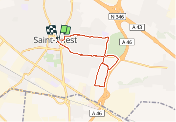
Trail Walking of 6.5 km to be discovered at Auvergne-Rhône-Alpes, Métropole de Lyon, Saint-Priest. This trail is proposed by jtraverse.
Positioning
Country:
France
Region :
Auvergne-Rhône-Alpes
Department/Province :
Métropole de Lyon
Municipality :
Saint-Priest
Location:
Unknown
Start:(Dec)
Start:(UTM)
651481 ; 5062129 (31T) N.
Comments