


Tt

olivieraron
User
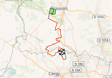

Length
77 km

Max alt
229 m

Uphill gradient
850 m
Km-Effort
88 km

Min alt
42 m

Downhill gradient
943 m
Boucle
No
Creation date :
2020-05-20 10:08:00.0
Updated on :
2020-05-20 15:29:35.651
2h59
Difficulty : Unknown

FREE GPS app for hiking
 SityTrail
IGN / Geographical institutes
SityTrail Plus
The world is yours!
About
Trail Motorbike of 77 km to be discovered at Hauts-de-France, Oise, Auneuil. This trail is proposed by olivieraron.
Positioning
Country:
France
Region :
Hauts-de-France
Department/Province :
Oise
Municipality :
Auneuil
Location:
Auneuil
Start:(Dec)
Start:(UTM)
426518 ; 5469240 (31U) N.
Comments