


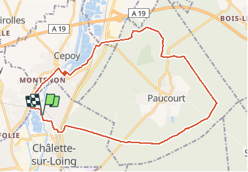
rando 20 mai 2020

paul01
User

Length
20 km

Max alt
132 m

Uphill gradient
225 m
Km-Effort
23 km

Min alt
75 m

Downhill gradient
225 m
Boucle
Yes
Creation date :
2020-05-20 11:02:35.95
Updated on :
2020-05-20 16:40:25.338
5h12
Difficulty : Medium

FREE GPS app for hiking
 SityTrail
IGN / Geographical institutes
SityTrail Plus
The world is yours!
About
Trail Walking of 20 km to be discovered at Centre-Loire Valley, Loiret, Chalette-sur-Loing. This trail is proposed by paul01.
Positioning
Country:
France
Region :
Centre-Loire Valley
Department/Province :
Loiret
Municipality :
Chalette-sur-Loing
Location:
Unknown
Start:(Dec)
Start:(UTM)
479949 ; 5319609 (31U) N.
Comments