


cartayre

lablaquiere
User
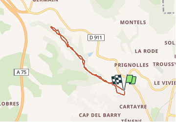

Length
6.5 km

Max alt
589 m

Uphill gradient
220 m
Km-Effort
9.4 km

Min alt
409 m

Downhill gradient
216 m
Boucle
Yes
Creation date :
2020-05-20 16:20:30.127
Updated on :
2020-05-20 17:23:37.275
1h02
Difficulty : Very easy

FREE GPS app for hiking
 SityTrail
IGN / Geographical institutes
SityTrail Plus
The world is yours!
About
Trail Running of 6.5 km to be discovered at Occitania, Aveyron, Millau. This trail is proposed by lablaquiere.
Positioning
Country:
France
Region :
Occitania
Department/Province :
Aveyron
Municipality :
Millau
Location:
Unknown
Start:(Dec)
Start:(UTM)
505236 ; 4884481 (31T) N.
Comments