


Ollioules - La courtine

affinetataille
User GUIDE
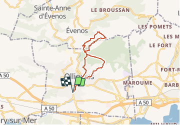

Length
11.6 km

Max alt
470 m

Uphill gradient
490 m
Km-Effort
18.1 km

Min alt
34 m

Downhill gradient
490 m
Boucle
Yes
Creation date :
2020-05-21 04:54:46.535
Updated on :
2020-05-21 18:34:54.361
4h09
Difficulty : Medium

FREE GPS app for hiking
 SityTrail
IGN / Geographical institutes
SityTrail Plus
The world is yours!
About
Trail Walking of 11.6 km to be discovered at Provence-Alpes-Côte d'Azur, Var, Ollioules. This trail is proposed by affinetataille.
Positioning
Country:
France
Region :
Provence-Alpes-Côte d'Azur
Department/Province :
Var
Municipality :
Ollioules
Location:
Unknown
Start:(Dec)
Start:(UTM)
731359 ; 4779371 (31T) N.
Comments