


Sicié sentier sud et les crêtes

bernir
User
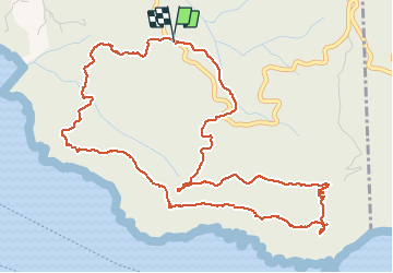

Length
7.2 km

Max alt
298 m

Uphill gradient
332 m
Km-Effort
11.7 km

Min alt
103 m

Downhill gradient
332 m
Boucle
Yes
Creation date :
2020-05-20 07:15:04.584
Updated on :
2020-05-21 10:01:04.94
4h10
Difficulty : Easy

FREE GPS app for hiking
 SityTrail
IGN / Geographical institutes
SityTrail Plus
The world is yours!
About
Trail Walking of 7.2 km to be discovered at Provence-Alpes-Côte d'Azur, Var, Six-Fours-les-Plages. This trail is proposed by bernir.
Positioning
Country:
France
Region :
Provence-Alpes-Côte d'Azur
Department/Province :
Var
Municipality :
Six-Fours-les-Plages
Location:
Unknown
Start:(Dec)
Start:(UTM)
730604 ; 4771471 (31T) N.
Comments