


Charpey

meillon
User
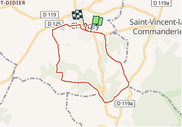

Length
7.8 km

Max alt
399 m

Uphill gradient
161 m
Km-Effort
9.9 km

Min alt
275 m

Downhill gradient
139 m
Boucle
No
Creation date :
2020-05-22 08:20:16.607
Updated on :
2020-05-22 10:44:17.647
2h23
Difficulty : Very easy

FREE GPS app for hiking
 SityTrail
IGN / Geographical institutes
SityTrail Plus
The world is yours!
About
Trail Walking of 7.8 km to be discovered at Auvergne-Rhône-Alpes, Drôme, Charpey. This trail is proposed by meillon.
Description
Agréable randonnée
Positioning
Country:
France
Region :
Auvergne-Rhône-Alpes
Department/Province :
Drôme
Municipality :
Charpey
Location:
Unknown
Start:(Dec)
Start:(UTM)
665302 ; 4978102 (31T) N.
Comments