


Eguieres Opies4

Nathy8913
User
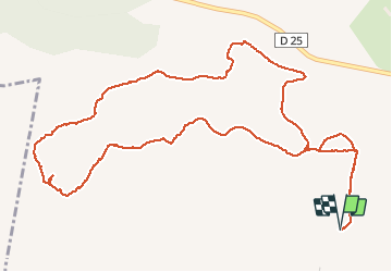

Length
7.5 km

Max alt
479 m

Uphill gradient
356 m
Km-Effort
12.3 km

Min alt
134 m

Downhill gradient
356 m
Boucle
Yes
Creation date :
2020-05-22 07:50:24.033
Updated on :
2020-05-22 12:17:26.41
3h45
Difficulty : Medium

FREE GPS app for hiking
 SityTrail
IGN / Geographical institutes
SityTrail Plus
The world is yours!
About
Trail Walking of 7.5 km to be discovered at Provence-Alpes-Côte d'Azur, Bouches-du-Rhône, Eyguières. This trail is proposed by Nathy8913.
Positioning
Country:
France
Region :
Provence-Alpes-Côte d'Azur
Department/Province :
Bouches-du-Rhône
Municipality :
Eyguières
Location:
Unknown
Start:(Dec)
Start:(UTM)
661587 ; 4841528 (31T) N.
Comments