


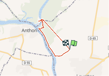
01 Confluence Ain Rhône

trietsch
User

Length
6.3 km

Max alt
197 m

Uphill gradient
31 m
Km-Effort
6.7 km

Min alt
189 m

Downhill gradient
32 m
Boucle
Yes
Creation date :
2020-05-22 09:29:36.0
Updated on :
2020-05-23 11:58:38.524
1h15
Difficulty : Unknown

FREE GPS app for hiking
 SityTrail
IGN / Geographical institutes
SityTrail Plus
The world is yours!
About
Trail Walking of 6.3 km to be discovered at Auvergne-Rhône-Alpes, Ain, Loyettes. This trail is proposed by trietsch.
Description
Sortie proposée par Dominique et Phuong
Positioning
Country:
France
Region :
Auvergne-Rhône-Alpes
Department/Province :
Ain
Municipality :
Loyettes
Location:
Unknown
Start:(Dec)
Start:(UTM)
670751 ; 5072426 (31T) N.
Comments