


Rando du 23 05 20- 5.8 a79

jtraverse
User
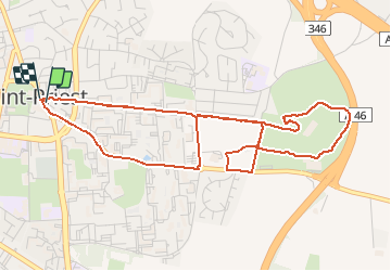

Length
5.8 km

Max alt
258 m

Uphill gradient
74 m
Km-Effort
6.8 km

Min alt
219 m

Downhill gradient
74 m
Boucle
Yes
Creation date :
2020-05-23 06:12:51.158
Updated on :
2020-05-23 10:27:32.125
1h43
Difficulty : Very easy

FREE GPS app for hiking
 SityTrail
IGN / Geographical institutes
SityTrail Plus
The world is yours!
About
Trail Walking of 5.8 km to be discovered at Auvergne-Rhône-Alpes, Métropole de Lyon, Saint-Priest. This trail is proposed by jtraverse.
Positioning
Country:
France
Region :
Auvergne-Rhône-Alpes
Department/Province :
Métropole de Lyon
Municipality :
Saint-Priest
Location:
Unknown
Start:(Dec)
Start:(UTM)
651449 ; 5062127 (31T) N.
Comments