


dentelles

mthomas30
User
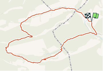

Length
6.9 km

Max alt
584 m

Uphill gradient
353 m
Km-Effort
11.6 km

Min alt
255 m

Downhill gradient
352 m
Boucle
Yes
Creation date :
2020-05-23 07:27:02.347
Updated on :
2020-05-23 11:41:50.725
4h13
Difficulty : Medium

FREE GPS app for hiking
 SityTrail
IGN / Geographical institutes
SityTrail Plus
The world is yours!
About
Trail Walking of 6.9 km to be discovered at Provence-Alpes-Côte d'Azur, Vaucluse, Lafare. This trail is proposed by mthomas30.
Positioning
Country:
France
Region :
Provence-Alpes-Côte d'Azur
Department/Province :
Vaucluse
Municipality :
Lafare
Location:
Unknown
Start:(Dec)
Start:(UTM)
663566 ; 4891580 (31T) N.
Comments