


navacelles

vertygo
User
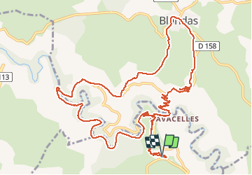

Length
16.4 km

Max alt
669 m

Uphill gradient
690 m
Km-Effort
26 km

Min alt
330 m

Downhill gradient
687 m
Boucle
Yes
Creation date :
2020-05-18 08:31:21.694
Updated on :
2020-05-23 17:46:37.45
5h12
Difficulty : Medium

FREE GPS app for hiking
 SityTrail
IGN / Geographical institutes
SityTrail Plus
The world is yours!
About
Trail Walking of 16.4 km to be discovered at Occitania, Hérault, Saint-Maurice-Navacelles. This trail is proposed by vertygo.
Positioning
Country:
France
Region :
Occitania
Department/Province :
Hérault
Municipality :
Saint-Maurice-Navacelles
Location:
Unknown
Start:(Dec)
Start:(UTM)
540854 ; 4859505 (31T) N.
Comments