


la breche d'enfloquet

viam19
User
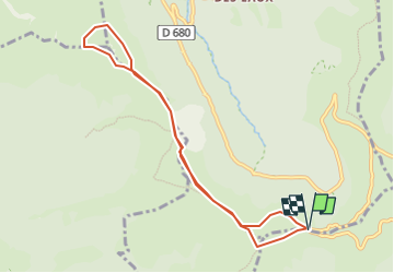

Length
8.7 km

Max alt
1634 m

Uphill gradient
489 m
Km-Effort
15.2 km

Min alt
1481 m

Downhill gradient
488 m
Boucle
Yes
Creation date :
2020-05-24 15:03:56.215
Updated on :
2025-06-11 22:44:37.726
3h04
Difficulty : Difficult

FREE GPS app for hiking
 SityTrail
IGN / Geographical institutes
SityTrail Plus
The world is yours!
About
Trail Walking of 8.7 km to be discovered at Auvergne-Rhône-Alpes, Cantal, Le Falgoux. This trail is proposed by viam19.
Positioning
Country:
France
Region :
Auvergne-Rhône-Alpes
Department/Province :
Cantal
Municipality :
Le Falgoux
Location:
Unknown
Start:(Dec)
Start:(UTM)
473405 ; 4994616 (31T) N.
Comments