


tête de la jaquette

orsel
User GUIDE
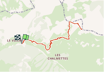

Length
11.8 km

Max alt
2749 m

Uphill gradient
985 m
Km-Effort
25 km

Min alt
1787 m

Downhill gradient
986 m
Boucle
Yes
Creation date :
2020-05-24 06:45:40.633
Updated on :
2020-05-24 15:05:41.939
5h32
Difficulty : Medium

FREE GPS app for hiking
 SityTrail
IGN / Geographical institutes
SityTrail Plus
The world is yours!
About
Trail Walking of 11.8 km to be discovered at Provence-Alpes-Côte d'Azur, Hautes-Alpes, Ceillac. This trail is proposed by orsel.
Description
avec Claire et Lucien
Positioning
Country:
France
Region :
Provence-Alpes-Côte d'Azur
Department/Province :
Hautes-Alpes
Municipality :
Ceillac
Location:
Unknown
Start:(Dec)
Start:(UTM)
325482 ; 4949227 (32T) N.
Comments