Trail On foot Alaincourt-la-Côte - Boucle au sud-ouest d'Alaincourt-La-Côte - Photo

Boucle au sud-ouest d'Alaincourt-La-Côte

 GXVII
GXVII

User

© OpenStreetMap contributors
Length
Length
8.9 km
Max alt
Max alt
261 m
Uphill gradient
Uphill gradient
103 m
Km-Effort
Km-Effort  
10.2 km
Min alt
Min alt
183 m
Downhill gradient
Downhill gradient
101 m
Boucle
Boucle
Yes
Creation date :
2020-05-25 07:25:12.549
Updated on :
2020-05-25 07:51:52.026

(0 Reviews)

On foot
On foot
--
Difficulty : Medium
Mountain bike
Mountain bike
41m
Difficulty : Medium
Equestrian
Equestrian
--
Difficulty : Easy

Scan this QR Code to open this trail in the SityTrail application

FREE GPS app for hiking

Logo SityTrail SityTrail

IGN / Geographical institutes

Download SityTrail from the App Store Download SityTrail from Google Play

Logo SityTrail SityTrail World

The world is yours!

Download SityTrail from the App Store Download SityTrail from Google Play Download SityTrail on Huawei AppGallery

About

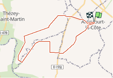
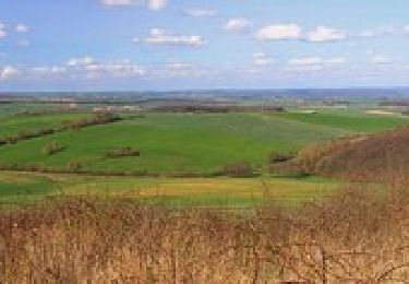
Trail On foot of 8.9 km to be discovered at Grand Est, Moselle, Alaincourt-la-Côte. This trail is proposed by GXVII.

Description

Parcours facilement accessible à cheval, vtt et à pied.
Il est préférable d'éviter les passages en véhicules motorisés pour la préservation des chemins, surtout plus fragiles aux abords du ruisseau.
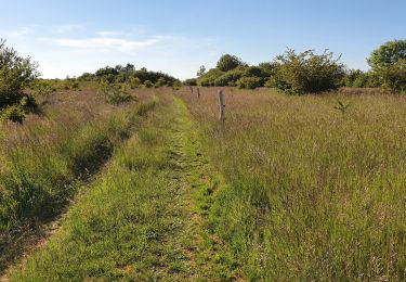
Avant d'arriver au ruisseau, des hautes herbes peuvent surgir quelques cervidés. Attention aux écarts avec certains chevaux...
Le long du ruisseau, qui dit eau, dit insectes volants, équipez-vous pour ne pas être trop incommodé…
Bonne promenade

Elevation profile

Positioning

Country:
France
Region :
Grand Est
Department/Province :
Moselle
Municipality :
Alaincourt-la-Côte
Location:
Unknown
Start:(UTM)
305228 ; 5419654 (32U) N.

Trails nearby

Trail Walking Juville - côte de Delme - Photo
Walking
viverols

Walking

Very easy
Juville, Grand Est, Moselle, France
6.9 km | 8.2 km-effort
1h 50min
Yes
Trail Walking Chenicourt - chenicourt (54) - Photo
Walking
Jacques-WIRTH

Walking

Very easy
Chenicourt, Grand Est, Meurthe-et-Moselle, France
8.4 km | 9.5 km-effort
2h 44min
Yes
Trail Mountain bike Delme - La butte du Haut du Mont - Delme - Photo
Mountain bike
tracegps

Mountain bike

Medium
(1)
Delme, Grand Est, Moselle, France
34 km | 42 km-effort
2h 0min
Yes
Trail Cycle Delme - Circuit de la côte de Delme - Photo
Cycle
tracegps

Cycle

Difficult
Delme, Grand Est, Moselle, France
37 km | 43 km-effort
2h 15min
Yes
Trail Walking Delme - cote fe delme anemone pilstille5 4 23anemones fleuries - Photo
Walking
jerome-dupont@laposte.net

Walking

Difficult
Delme, Grand Est, Moselle, France
12.8 km | 17.3 km-effort
3h 26min
No
Trail Horseback riding Alaincourt-la-Côte - Balade  - Photo
Horseback riding
Maminou57

Horseback riding

Easy
Alaincourt-la-Côte, Grand Est, Moselle, France
10.6 km | 12.2 km-effort
2h 9min
Yes
Trail Car Tragny - tyty - Photo
Car
Bob5757

Car

Very easy
Tragny, Grand Est, Moselle, France
3.8 km | 4.8 km-effort
1h 4min
No
Trail Mountain bike Delme - Rando VTT (2017) De la Cote de Delme (57)  - Photo
Mountain bike
pirate54

Mountain bike

Medium
Delme, Grand Est, Moselle, France
44 km | 54 km-effort
2h 34min
Yes
Trail Walking Phlin - le Fouyeu - Photo
Walking
DanielROLLET

Walking

Medium
Phlin, Grand Est, Meurthe-et-Moselle, France
1.8 km | 2.6 km-effort
1h 29min
No


Close
My subscriptions