


Château - Aulnois - Château du 26/05/2020

VANDERPUTTENMi
User GUIDE
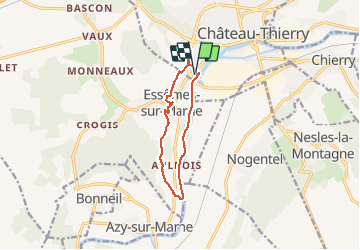

Length
9.2 km

Max alt
155 m

Uphill gradient
145 m
Km-Effort
11.1 km

Min alt
54 m

Downhill gradient
145 m
Boucle
Yes
Creation date :
2020-05-26 07:04:56.293
Updated on :
2020-05-26 14:31:34.709
2h04
Difficulty : Very easy

FREE GPS app for hiking
 SityTrail
IGN / Geographical institutes
SityTrail Plus
The world is yours!
About
Trail Walking of 9.2 km to be discovered at Hauts-de-France, Aisne, Château-Thierry. This trail is proposed by VANDERPUTTENMi.
Description
Départ depuis le parking de la base nautique.
Photos


Positioning
Country:
France
Region :
Hauts-de-France
Department/Province :
Aisne
Municipality :
Château-Thierry
Location:
Unknown
Start:(Dec)
Start:(UTM)
527976 ; 5431575 (31U) N.
Comments