


seillons source d"argent

marchev
User
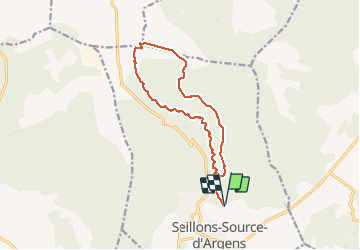

Length
13.8 km

Max alt
520 m

Uphill gradient
230 m
Km-Effort
16.8 km

Min alt
307 m

Downhill gradient
229 m
Boucle
Yes
Creation date :
2020-05-26 08:19:10.06
Updated on :
2020-05-27 06:17:51.532
4h42
Difficulty : Medium

FREE GPS app for hiking
 SityTrail
IGN / Geographical institutes
SityTrail Plus
The world is yours!
About
Trail Walking of 13.8 km to be discovered at Provence-Alpes-Côte d'Azur, Var, Seillons-Source-d'Argens. This trail is proposed by marchev.
Description
randonnée un peu monotone. Il faut pour terminer faire la visite du village
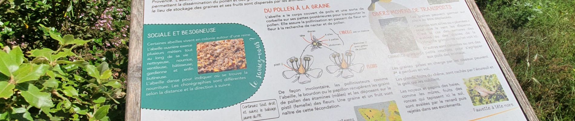
Photos
"
data-pinterest-text="Pin it"
data-tweet-text="share on twitter"
data-facebook-share-url="https://www.sitytrail.com/en/trails/2411962-seillonsxsourcexdxargens--seillons-source-dxargent/?photo=0#lg=1&slide=0"
data-twitter-share-url="https://www.sitytrail.com/en/trails/2411962-seillonsxsourcexdxargens--seillons-source-dxargent/?photo=0#lg=1&slide=0"
data-googleplus-share-url="https://www.sitytrail.com/en/trails/2411962-seillonsxsourcexdxargens--seillons-source-dxargent/?photo=0#lg=1&slide=0"
data-pinterest-share-url="https://www.sitytrail.com/en/trails/2411962-seillonsxsourcexdxargens--seillons-source-dxargent/?photo=0#lg=1&slide=0">
 "
data-pinterest-text="Pin it"
data-tweet-text="share on twitter"
data-facebook-share-url="https://www.sitytrail.com/en/trails/2411962-seillonsxsourcexdxargens--seillons-source-dxargent/?photo=1#lg=1&slide=1"
data-twitter-share-url="https://www.sitytrail.com/en/trails/2411962-seillonsxsourcexdxargens--seillons-source-dxargent/?photo=1#lg=1&slide=1"
data-googleplus-share-url="https://www.sitytrail.com/en/trails/2411962-seillonsxsourcexdxargens--seillons-source-dxargent/?photo=1#lg=1&slide=1"
data-pinterest-share-url="https://www.sitytrail.com/en/trails/2411962-seillonsxsourcexdxargens--seillons-source-dxargent/?photo=1#lg=1&slide=1">
"
data-pinterest-text="Pin it"
data-tweet-text="share on twitter"
data-facebook-share-url="https://www.sitytrail.com/en/trails/2411962-seillonsxsourcexdxargens--seillons-source-dxargent/?photo=1#lg=1&slide=1"
data-twitter-share-url="https://www.sitytrail.com/en/trails/2411962-seillonsxsourcexdxargens--seillons-source-dxargent/?photo=1#lg=1&slide=1"
data-googleplus-share-url="https://www.sitytrail.com/en/trails/2411962-seillonsxsourcexdxargens--seillons-source-dxargent/?photo=1#lg=1&slide=1"
data-pinterest-share-url="https://www.sitytrail.com/en/trails/2411962-seillonsxsourcexdxargens--seillons-source-dxargent/?photo=1#lg=1&slide=1">
 "
data-pinterest-text="Pin it"
data-tweet-text="share on twitter"
data-facebook-share-url="https://www.sitytrail.com/en/trails/2411962-seillonsxsourcexdxargens--seillons-source-dxargent/?photo=2#lg=1&slide=2"
data-twitter-share-url="https://www.sitytrail.com/en/trails/2411962-seillonsxsourcexdxargens--seillons-source-dxargent/?photo=2#lg=1&slide=2"
data-googleplus-share-url="https://www.sitytrail.com/en/trails/2411962-seillonsxsourcexdxargens--seillons-source-dxargent/?photo=2#lg=1&slide=2"
data-pinterest-share-url="https://www.sitytrail.com/en/trails/2411962-seillonsxsourcexdxargens--seillons-source-dxargent/?photo=2#lg=1&slide=2">
"
data-pinterest-text="Pin it"
data-tweet-text="share on twitter"
data-facebook-share-url="https://www.sitytrail.com/en/trails/2411962-seillonsxsourcexdxargens--seillons-source-dxargent/?photo=2#lg=1&slide=2"
data-twitter-share-url="https://www.sitytrail.com/en/trails/2411962-seillonsxsourcexdxargens--seillons-source-dxargent/?photo=2#lg=1&slide=2"
data-googleplus-share-url="https://www.sitytrail.com/en/trails/2411962-seillonsxsourcexdxargens--seillons-source-dxargent/?photo=2#lg=1&slide=2"
data-pinterest-share-url="https://www.sitytrail.com/en/trails/2411962-seillonsxsourcexdxargens--seillons-source-dxargent/?photo=2#lg=1&slide=2">
 "
data-pinterest-text="Pin it"
data-tweet-text="share on twitter"
data-facebook-share-url="https://www.sitytrail.com/en/trails/2411962-seillonsxsourcexdxargens--seillons-source-dxargent/?photo=3#lg=1&slide=3"
data-twitter-share-url="https://www.sitytrail.com/en/trails/2411962-seillonsxsourcexdxargens--seillons-source-dxargent/?photo=3#lg=1&slide=3"
data-googleplus-share-url="https://www.sitytrail.com/en/trails/2411962-seillonsxsourcexdxargens--seillons-source-dxargent/?photo=3#lg=1&slide=3"
data-pinterest-share-url="https://www.sitytrail.com/en/trails/2411962-seillonsxsourcexdxargens--seillons-source-dxargent/?photo=3#lg=1&slide=3">
"
data-pinterest-text="Pin it"
data-tweet-text="share on twitter"
data-facebook-share-url="https://www.sitytrail.com/en/trails/2411962-seillonsxsourcexdxargens--seillons-source-dxargent/?photo=3#lg=1&slide=3"
data-twitter-share-url="https://www.sitytrail.com/en/trails/2411962-seillonsxsourcexdxargens--seillons-source-dxargent/?photo=3#lg=1&slide=3"
data-googleplus-share-url="https://www.sitytrail.com/en/trails/2411962-seillonsxsourcexdxargens--seillons-source-dxargent/?photo=3#lg=1&slide=3"
data-pinterest-share-url="https://www.sitytrail.com/en/trails/2411962-seillonsxsourcexdxargens--seillons-source-dxargent/?photo=3#lg=1&slide=3">

 "
data-pinterest-text="Pin it"
data-tweet-text="share on twitter"
data-facebook-share-url="https://www.sitytrail.com/en/trails/2411962-seillonsxsourcexdxargens--seillons-source-dxargent/?photo=1#lg=1&slide=1"
data-twitter-share-url="https://www.sitytrail.com/en/trails/2411962-seillonsxsourcexdxargens--seillons-source-dxargent/?photo=1#lg=1&slide=1"
data-googleplus-share-url="https://www.sitytrail.com/en/trails/2411962-seillonsxsourcexdxargens--seillons-source-dxargent/?photo=1#lg=1&slide=1"
data-pinterest-share-url="https://www.sitytrail.com/en/trails/2411962-seillonsxsourcexdxargens--seillons-source-dxargent/?photo=1#lg=1&slide=1">
"
data-pinterest-text="Pin it"
data-tweet-text="share on twitter"
data-facebook-share-url="https://www.sitytrail.com/en/trails/2411962-seillonsxsourcexdxargens--seillons-source-dxargent/?photo=1#lg=1&slide=1"
data-twitter-share-url="https://www.sitytrail.com/en/trails/2411962-seillonsxsourcexdxargens--seillons-source-dxargent/?photo=1#lg=1&slide=1"
data-googleplus-share-url="https://www.sitytrail.com/en/trails/2411962-seillonsxsourcexdxargens--seillons-source-dxargent/?photo=1#lg=1&slide=1"
data-pinterest-share-url="https://www.sitytrail.com/en/trails/2411962-seillonsxsourcexdxargens--seillons-source-dxargent/?photo=1#lg=1&slide=1">
 "
data-pinterest-text="Pin it"
data-tweet-text="share on twitter"
data-facebook-share-url="https://www.sitytrail.com/en/trails/2411962-seillonsxsourcexdxargens--seillons-source-dxargent/?photo=2#lg=1&slide=2"
data-twitter-share-url="https://www.sitytrail.com/en/trails/2411962-seillonsxsourcexdxargens--seillons-source-dxargent/?photo=2#lg=1&slide=2"
data-googleplus-share-url="https://www.sitytrail.com/en/trails/2411962-seillonsxsourcexdxargens--seillons-source-dxargent/?photo=2#lg=1&slide=2"
data-pinterest-share-url="https://www.sitytrail.com/en/trails/2411962-seillonsxsourcexdxargens--seillons-source-dxargent/?photo=2#lg=1&slide=2">
"
data-pinterest-text="Pin it"
data-tweet-text="share on twitter"
data-facebook-share-url="https://www.sitytrail.com/en/trails/2411962-seillonsxsourcexdxargens--seillons-source-dxargent/?photo=2#lg=1&slide=2"
data-twitter-share-url="https://www.sitytrail.com/en/trails/2411962-seillonsxsourcexdxargens--seillons-source-dxargent/?photo=2#lg=1&slide=2"
data-googleplus-share-url="https://www.sitytrail.com/en/trails/2411962-seillonsxsourcexdxargens--seillons-source-dxargent/?photo=2#lg=1&slide=2"
data-pinterest-share-url="https://www.sitytrail.com/en/trails/2411962-seillonsxsourcexdxargens--seillons-source-dxargent/?photo=2#lg=1&slide=2">
 "
data-pinterest-text="Pin it"
data-tweet-text="share on twitter"
data-facebook-share-url="https://www.sitytrail.com/en/trails/2411962-seillonsxsourcexdxargens--seillons-source-dxargent/?photo=3#lg=1&slide=3"
data-twitter-share-url="https://www.sitytrail.com/en/trails/2411962-seillonsxsourcexdxargens--seillons-source-dxargent/?photo=3#lg=1&slide=3"
data-googleplus-share-url="https://www.sitytrail.com/en/trails/2411962-seillonsxsourcexdxargens--seillons-source-dxargent/?photo=3#lg=1&slide=3"
data-pinterest-share-url="https://www.sitytrail.com/en/trails/2411962-seillonsxsourcexdxargens--seillons-source-dxargent/?photo=3#lg=1&slide=3">
"
data-pinterest-text="Pin it"
data-tweet-text="share on twitter"
data-facebook-share-url="https://www.sitytrail.com/en/trails/2411962-seillonsxsourcexdxargens--seillons-source-dxargent/?photo=3#lg=1&slide=3"
data-twitter-share-url="https://www.sitytrail.com/en/trails/2411962-seillonsxsourcexdxargens--seillons-source-dxargent/?photo=3#lg=1&slide=3"
data-googleplus-share-url="https://www.sitytrail.com/en/trails/2411962-seillonsxsourcexdxargens--seillons-source-dxargent/?photo=3#lg=1&slide=3"
data-pinterest-share-url="https://www.sitytrail.com/en/trails/2411962-seillonsxsourcexdxargens--seillons-source-dxargent/?photo=3#lg=1&slide=3">

Positioning
Country:
France
Region :
Provence-Alpes-Côte d'Azur
Department/Province :
Var
Municipality :
Seillons-Source-d'Argens
Location:
Unknown
Start:(Dec)
Start:(UTM)
733392 ; 4820814 (31T) N.
Comments