


Roche les Blamont

tiene
User

Length
22 km

Max alt
531 m

Uphill gradient
637 m
Km-Effort
30 km

Min alt
329 m

Downhill gradient
446 m
Boucle
No
Creation date :
2020-05-26 12:00:57.152
Updated on :
2020-05-26 13:52:47.186
1h51
Difficulty : Very easy

FREE GPS app for hiking
 SityTrail
IGN / Geographical institutes
SityTrail Plus
The world is yours!
About
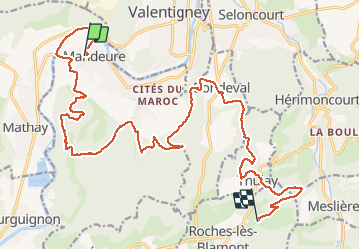
Trail Mountain bike of 22 km to be discovered at Bourgogne-Franche-Comté, Doubs, Mandeure. This trail is proposed by tiene.
Positioning
Country:
France
Region :
Bourgogne-Franche-Comté
Department/Province :
Doubs
Municipality :
Mandeure
Location:
Unknown
Start:(Dec)
Start:(UTM)
334312 ; 5257739 (32T) N.
Comments