


SityTrail - SityTrail - St Hilarion gazeran 11km5

cemoi
User
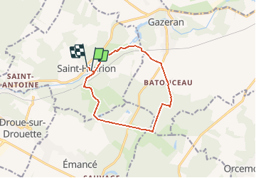

Length
10.9 km

Max alt
183 m

Uphill gradient
106 m
Km-Effort
12.3 km

Min alt
129 m

Downhill gradient
97 m
Boucle
Yes
Creation date :
2020-05-27 09:14:09.755
Updated on :
2020-05-30 11:55:42.73
--
Difficulty : Very easy

FREE GPS app for hiking
 SityTrail
IGN / Geographical institutes
SityTrail Plus
The world is yours!
About
Trail On foot of 10.9 km to be discovered at Ile-de-France, Yvelines, Saint-Hilarion. This trail is proposed by cemoi.
Positioning
Country:
France
Region :
Ile-de-France
Department/Province :
Yvelines
Municipality :
Saint-Hilarion
Location:
Unknown
Start:(Dec)
Start:(UTM)
406839 ; 5385900 (31U) N.
Comments