


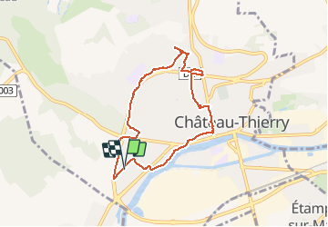
Marche dans Château du 27/05/2020

VANDERPUTTENMi
User GUIDE

Length
6.8 km

Max alt
128 m

Uphill gradient
102 m
Km-Effort
8.2 km

Min alt
57 m

Downhill gradient
103 m
Boucle
Yes
Creation date :
2020-05-27 08:23:52.529
Updated on :
2020-05-27 09:51:52.275
1h28
Difficulty : Very easy

FREE GPS app for hiking
 SityTrail
IGN / Geographical institutes
SityTrail Plus
The world is yours!
About
Trail Walking of 6.8 km to be discovered at Hauts-de-France, Aisne, Château-Thierry. This trail is proposed by VANDERPUTTENMi.
Positioning
Country:
France
Region :
Hauts-de-France
Department/Province :
Aisne
Municipality :
Château-Thierry
Location:
Unknown
Start:(Dec)
Start:(UTM)
527951 ; 5431973 (31U) N.
Comments