


ACTIVE LOG 003

mitch1952
User
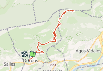

Length
12.3 km

Max alt
1340 m

Uphill gradient
809 m
Km-Effort
23 km

Min alt
580 m

Downhill gradient
809 m
Boucle
Yes
Creation date :
2020-05-27 11:31:41.437
Updated on :
2022-06-07 09:53:12.169
2h30
Difficulty : Medium

FREE GPS app for hiking
 SityTrail
IGN / Geographical institutes
SityTrail Plus
The world is yours!
About
Trail On foot of 12.3 km to be discovered at Occitania, Hautespyrenees, Ouzous. This trail is proposed by mitch1952.
Positioning
Country:
France
Region :
Occitania
Department/Province :
Hautespyrenees
Municipality :
Ouzous
Location:
Unknown
Start:(Dec)
Start:(UTM)
735624 ; 4768205 (30T) N.
Comments