


2020-05-27 Col du Pigeonnier - Ruines de la Chapelle - Col du Pigeonnier

maureengeorges
User
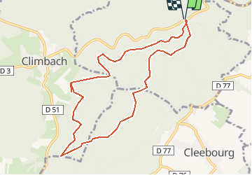

Length
9.4 km

Max alt
491 m

Uphill gradient
264 m
Km-Effort
12.9 km

Min alt
397 m

Downhill gradient
264 m
Boucle
Yes
Creation date :
2020-05-27 13:24:18.448
Updated on :
2020-05-27 13:25:38.138
2h43
Difficulty : Difficult

FREE GPS app for hiking
 SityTrail
IGN / Geographical institutes
SityTrail Plus
The world is yours!
About
Trail Walking of 9.4 km to be discovered at Grand Est, Bas-Rhin, Wissembourg. This trail is proposed by maureengeorges.
Positioning
Country:
France
Region :
Grand Est
Department/Province :
Bas-Rhin
Municipality :
Wissembourg
Location:
Unknown
Start:(Dec)
Start:(UTM)
418538 ; 5430803 (32U) N.
Comments