


reconnaissance 28 05 20 - 8.1km à 78m

jtraverse
User
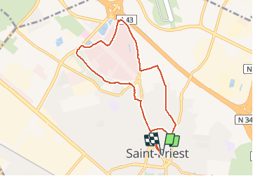

Length
8.1 km

Max alt
227 m

Uphill gradient
78 m
Km-Effort
9.1 km

Min alt
199 m

Downhill gradient
78 m
Boucle
Yes
Creation date :
2020-05-27 11:44:07.161
Updated on :
2020-05-28 06:13:27.426
2h17
Difficulty : Very easy

FREE GPS app for hiking
 SityTrail
IGN / Geographical institutes
SityTrail Plus
The world is yours!
About
Trail Walking of 8.1 km to be discovered at Auvergne-Rhône-Alpes, Métropole de Lyon, Saint-Priest. This trail is proposed by jtraverse.
Description
2km de goudron pour commencer-essayer de modifier
Positioning
Country:
France
Region :
Auvergne-Rhône-Alpes
Department/Province :
Métropole de Lyon
Municipality :
Saint-Priest
Location:
Unknown
Start:(Dec)
Start:(UTM)
651464 ; 5062127 (31T) N.
Comments