


montclus et bord de ceze

Dan30
User
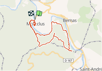

Length
10.4 km

Max alt
203 m

Uphill gradient
260 m
Km-Effort
13.9 km

Min alt
80 m

Downhill gradient
260 m
Boucle
Yes
Creation date :
2020-05-28 07:31:41.37
Updated on :
2020-05-28 14:45:19.542
4h10
Difficulty : Medium

FREE GPS app for hiking
 SityTrail
IGN / Geographical institutes
SityTrail Plus
The world is yours!
About
Trail Walking of 10.4 km to be discovered at Occitania, Gard, Montclus. This trail is proposed by Dan30.
Photos


Positioning
Country:
France
Region :
Occitania
Department/Province :
Gard
Municipality :
Montclus
Location:
Unknown
Start:(Dec)
Start:(UTM)
613377 ; 4902035 (31T) N.
Comments