


Boucle 2 SLDP

choubaka77
User

Length
28 km

Max alt
508 m

Uphill gradient
409 m
Km-Effort
33 km

Min alt
367 m

Downhill gradient
407 m
Boucle
Yes
Creation date :
2020-05-28 16:17:04.0
Updated on :
2020-05-28 18:43:47.606
2h26
Difficulty : Difficult

FREE GPS app for hiking
 SityTrail
IGN / Geographical institutes
SityTrail Plus
The world is yours!
About
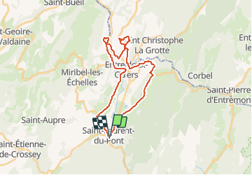
Trail Road bike of 28 km to be discovered at Auvergne-Rhône-Alpes, Isère, Saint-Laurent-du-Pont. This trail is proposed by choubaka77.
Positioning
Country:
France
Region :
Auvergne-Rhône-Alpes
Department/Province :
Isère
Municipality :
Saint-Laurent-du-Pont
Location:
Unknown
Start:(Dec)
Start:(UTM)
714158 ; 5029562 (31T) N.
Comments