


charrier super retour chalandre

aml63
User
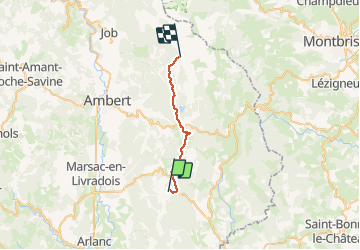

Length
21 km

Max alt
1390 m

Uphill gradient
726 m
Km-Effort
29 km

Min alt
974 m

Downhill gradient
344 m
Boucle
No
Creation date :
2020-05-29 12:23:43.162
Updated on :
2020-05-29 12:24:56.524
1h56
Difficulty : Medium

FREE GPS app for hiking
 SityTrail
IGN / Geographical institutes
SityTrail Plus
The world is yours!
About
Trail Mountain bike of 21 km to be discovered at Auvergne-Rhône-Alpes, Puy-de-Dôme, Baffie. This trail is proposed by aml63.
Positioning
Country:
France
Region :
Auvergne-Rhône-Alpes
Department/Province :
Puy-de-Dôme
Municipality :
Baffie
Location:
Unknown
Start:(Dec)
Start:(UTM)
564733 ; 5034628 (31T) N.
Comments