


Veigné - boucles via GR46A - 19.9km 210m 4h20 - 2020 05 29

Orcal37
User GUIDE
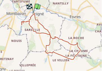

Length
19.9 km

Max alt
96 m

Uphill gradient
215 m
Km-Effort
23 km

Min alt
53 m

Downhill gradient
214 m
Boucle
Yes
Creation date :
2020-05-29 12:37:50.452
Updated on :
2021-09-08 13:18:22.155
4h20
Difficulty : Easy

FREE GPS app for hiking
 SityTrail
IGN / Geographical institutes
SityTrail Plus
The world is yours!
About
Trail Walking of 19.9 km to be discovered at Centre-Loire Valley, Indre-et-Loire, Veigné. This trail is proposed by Orcal37.
Description
Veigné - boucles via GR46A - 19.9km 210m 4h20 - 2020 05 29
Photos


Positioning
Country:
France
Region :
Centre-Loire Valley
Department/Province :
Indre-et-Loire
Municipality :
Veigné
Location:
Unknown
Start:(Dec)
Start:(UTM)
328781 ; 5239647 (31T) N.
Comments