


greffiers- la huniere

cemoi
User
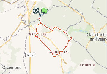

Length
11 km

Max alt
178 m

Uphill gradient
64 m
Km-Effort
11.9 km

Min alt
155 m

Downhill gradient
63 m
Boucle
Yes
Creation date :
2020-05-30 12:10:45.808
Updated on :
2020-05-30 12:11:39.739
--
Difficulty : Easy

FREE GPS app for hiking
 SityTrail
IGN / Geographical institutes
SityTrail Plus
The world is yours!
About
Trail On foot of 11 km to be discovered at Ile-de-France, Yvelines, Sonchamp. This trail is proposed by cemoi.
Positioning
Country:
France
Region :
Ile-de-France
Department/Province :
Yvelines
Municipality :
Sonchamp
Location:
Unknown
Start:(Dec)
Start:(UTM)
414813 ; 5386558 (31U) N.
Comments