


besancon

PatriceCocuaud
User
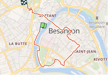

Length
4.3 km

Max alt
286 m

Uphill gradient
77 m
Km-Effort
5.2 km

Min alt
239 m

Downhill gradient
37 m
Boucle
No
Creation date :
2020-05-30 14:19:28.527
Updated on :
2020-05-30 16:32:38.606
1h40
Difficulty : Very easy

FREE GPS app for hiking
 SityTrail
IGN / Geographical institutes
SityTrail Plus
The world is yours!
About
Trail Walking of 4.3 km to be discovered at Bourgogne-Franche-Comté, Doubs, Besançon. This trail is proposed by PatriceCocuaud.
Positioning
Country:
France
Region :
Bourgogne-Franche-Comté
Department/Province :
Doubs
Municipality :
Besançon
Location:
Unknown
Start:(Dec)
Start:(UTM)
274256 ; 5235895 (32T) N.
Comments