


le Roc de la Vigne

ARVIEU
User
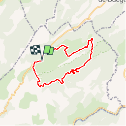

Length
13.6 km

Max alt
695 m

Uphill gradient
409 m
Km-Effort
19.1 km

Min alt
468 m

Downhill gradient
405 m
Boucle
Yes
Creation date :
2014-12-10 00:00:00.0
Updated on :
2014-12-10 00:00:00.0
4h04
Difficulty : Medium

FREE GPS app for hiking
 SityTrail
IGN / Geographical institutes
SityTrail Plus
The world is yours!
About
Trail Walking of 13.6 km to be discovered at Occitania, Hérault, Saint-Guilhem-le-Désert. This trail is proposed by ARVIEU.
Description
départs des Lavagnes en direction de Cap de Ginestet puis bifurcation par le Puech Bouissou, accès au Roc de la Vigne, retour par la Combe de Loubet
Positioning
Country:
France
Region :
Occitania
Department/Province :
Hérault
Municipality :
Saint-Guilhem-le-Désert
Location:
Unknown
Start:(Dec)
Start:(UTM)
543217 ; 4846806 (31T) N.
Comments