


Boucle Mousterian -Pointe de Bill

Ryry
User
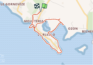

Length
4.8 km

Max alt
11 m

Uphill gradient
28 m
Km-Effort
5.2 km

Min alt
-1 m

Downhill gradient
28 m
Boucle
Yes
Creation date :
2020-05-31 07:35:49.344
Updated on :
2020-05-31 09:09:17.704
1h32
Difficulty : Very easy

FREE GPS app for hiking
 SityTrail
IGN / Geographical institutes
SityTrail Plus
The world is yours!
About
Trail Walking of 4.8 km to be discovered at Brittany, Morbihan, Séné. This trail is proposed by Ryry.
Positioning
Country:
France
Region :
Brittany
Department/Province :
Morbihan
Municipality :
Séné
Location:
Unknown
Start:(Dec)
Start:(UTM)
519703 ; 5272775 (30T) N.
Comments