


Ochsenstein 20200531

baggera
User
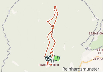

Length
7.8 km

Max alt
566 m

Uphill gradient
246 m
Km-Effort
11.1 km

Min alt
465 m

Downhill gradient
250 m
Boucle
Yes
Creation date :
2020-05-31 09:25:27.518
Updated on :
2020-05-31 14:12:53.042
3h48
Difficulty : Very easy

FREE GPS app for hiking
 SityTrail
IGN / Geographical institutes
SityTrail Plus
The world is yours!
About
Trail Walking of 7.8 km to be discovered at Grand Est, Bas-Rhin, Reinhardsmunster. This trail is proposed by baggera.
Positioning
Country:
France
Region :
Grand Est
Department/Province :
Bas-Rhin
Municipality :
Reinhardsmunster
Location:
Unknown
Start:(Dec)
Start:(UTM)
374921 ; 5393065 (32U) N.
Comments