


Saizenay Mont Poupet

i20
User
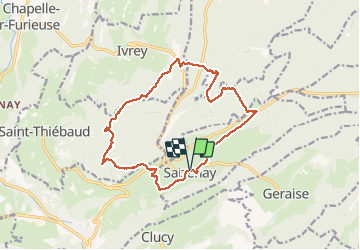

Length
15.6 km

Max alt
847 m

Uphill gradient
579 m
Km-Effort
23 km

Min alt
420 m

Downhill gradient
578 m
Boucle
Yes
Creation date :
2020-05-31 09:54:51.378
Updated on :
2020-05-31 17:57:08.028
5h20
Difficulty : Very easy

FREE GPS app for hiking
 SityTrail
IGN / Geographical institutes
SityTrail Plus
The world is yours!
About
Trail Walking of 15.6 km to be discovered at Bourgogne-Franche-Comté, Jura, Saizenay. This trail is proposed by i20.
Positioning
Country:
France
Region :
Bourgogne-Franche-Comté
Department/Province :
Jura
Municipality :
Saizenay
Location:
Unknown
Start:(Dec)
Start:(UTM)
721795 ; 5205113 (31T) N.
Comments