


GR 58 Tour du Queyras en 8 étapes - Jour 3

Kargil
User GUIDE
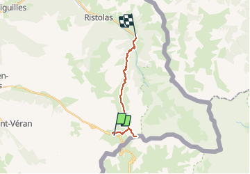

Length
14.3 km

Max alt
3078 m

Uphill gradient
549 m
Km-Effort
25 km

Min alt
1697 m

Downhill gradient
1414 m
Boucle
No
Creation date :
2020-05-31 18:21:24.216
Updated on :
2020-05-31 19:32:05.941
4h30
Difficulty : Very difficult

FREE GPS app for hiking
 SityTrail
IGN / Geographical institutes
SityTrail Plus
The world is yours!
About
Trail Walking of 14.3 km to be discovered at Provence-Alpes-Côte d'Azur, Hautes-Alpes, Molines-en-Queyras. This trail is proposed by Kargil.
Positioning
Country:
France
Region :
Provence-Alpes-Côte d'Azur
Department/Province :
Hautes-Alpes
Municipality :
Molines-en-Queyras
Location:
Unknown
Start:(Dec)
Start:(UTM)
339277 ; 4950612 (32T) N.
Comments