Trail Cycle Chevrières - CYCLO_La vallée de l'Automne - Photo

CYCLO_La vallée de l'Automne

© OpenStreetMap contributors
Length
Length
67 km
Max alt
Max alt
154 m
Uphill gradient
Uphill gradient
547 m
Km-Effort
Km-Effort  
74 km
Min alt
Min alt
27 m
Downhill gradient
Downhill gradient
541 m
Boucle
Boucle
Yes
Creation date :
2020-06-01 08:07:33.153
Updated on :
2020-06-01 08:10:40.32

(0 Reviews)

Cycle
Cycle
--
Difficulty : Very easy

Scan this QR Code to open this trail in the SityTrail application

FREE GPS app for hiking

Logo SityTrail SityTrail

IGN / Geographical institutes

Download SityTrail from the App Store Download SityTrail from Google Play

Logo SityTrail SityTrail World

The world is yours!

Download SityTrail from the App Store Download SityTrail from Google Play Download SityTrail on Huawei AppGallery

About

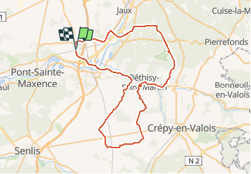
Trail Cycle of 67 km to be discovered at Hauts-de-France, Oise, Chevrières. This trail is proposed by Secmast Tours & Détours.

Description

Source: https://www.oisetourisme.com/randopic0600003b/la-vallee-de-lautomne/chevrieres

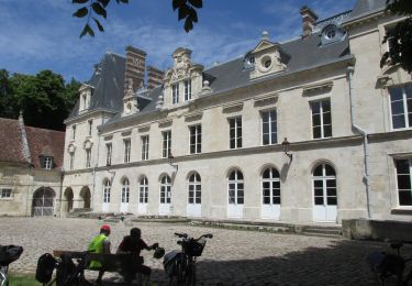
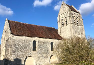
Dans l’Oise, l’Automne est aussi une rivière ! Et sa vallée est si riche en églises qu’on la surnomme la « vallée aux 35 clochers ». Vous commencez la visite de ce patrimoine religieux à Chevrières (vitraux remarquables), puis franchissez l’Oise en direction de Compiègne. Quelques kilomètres en forêt, et vous croisez d’autres jolis clochers sur le plateau du Valois.

Elevation profile

Positioning

Country:
France
Region :
Hauts-de-France
Department/Province :
Oise
Municipality :
Chevrières
Location:
Unknown
Start:(UTM)
476919 ; 5464949 (31U) N.

Trails nearby

Trail Hybrid bike Verberie - balade  vélo AU5V 15 mai - Photo
Hybrid bike
gilbertdu60

Hybrid bike

Easy
Verberie, Hauts-de-France, Oise, France
25 km | 28 km-effort
3h 36min
Yes
Trail Walking Roberval - Roberval - Photo
Walking
sabrigault

Walking

Medium
Roberval, Hauts-de-France, Oise, France
7.6 km | 9.5 km-effort
2h 19min
Yes
Trail Walking Grandfresnoy - Grandfresnoy - Photo
Walking
pascha

Walking

(1)
Grandfresnoy, Hauts-de-France, Oise, France
12.6 km | 14.7 km-effort
3h 17min
Yes
Trail Mountain bike Pontpoint - Montée D+ Bis - Photo
Mountain bike
laurantyann

Mountain bike

Difficult
(1)
Pontpoint, Hauts-de-France, Oise, France
3 km | 4.9 km-effort
20min
No
Trail Cycle Pont-Sainte-Maxence - AG2017 AU5V - Photo
Cycle
gilbertdu60

Cycle

Easy
Pont-Sainte-Maxence, Hauts-de-France, Oise, France
21 km | 23 km-effort
12min
Yes
Trail Walking Pont-Sainte-Maxence - pontpoint - Photo
Walking
jpld

Walking

Very easy
Pont-Sainte-Maxence, Hauts-de-France, Oise, France
9.2 km | 9.7 km-effort
1h 53min
Yes
Trail Mountain bike Pontpoint - Mont Pagnotte 54km - Photo
Mountain bike
fredvil60

Mountain bike

Very difficult
Pontpoint, Hauts-de-France, Oise, France
54 km | 64 km-effort
4h 16min
Yes
Trail Walking Pont-Sainte-Maxence - voie verte de l'évéché pontpoint - Photo
Walking
gilbertdu60

Walking

Easy
Pont-Sainte-Maxence, Hauts-de-France, Oise, France
6 km | 6.3 km-effort
1h 25min
Yes
Trail Other activity Le Fayel - le fayel mars 2014 - Photo
Other activity
pepite473360

Other activity

Medium
Le Fayel, Hauts-de-France, Oise, France
46 km | 54 km-effort
1h 58min
Yes


Close
My subscriptions