


Castillon - Argilliers - Boucles

mthomas30
User
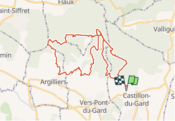

Length
25 km

Max alt
192 m

Uphill gradient
395 m
Km-Effort
30 km

Min alt
61 m

Downhill gradient
394 m
Boucle
Yes
Creation date :
2020-06-01 06:24:01.651
Updated on :
2020-07-13 10:34:43.884
2h43
Difficulty : Medium

FREE GPS app for hiking
 SityTrail
IGN / Geographical institutes
SityTrail Plus
The world is yours!
About
Trail Mountain bike of 25 km to be discovered at Occitania, Gard, Castillon-du-Gard. This trail is proposed by mthomas30.
Description
Sur les traces du club des crickets de Remoulins. Départ chapelle St Caprés, Belle boucle plein de monotraces.
Positioning
Country:
France
Region :
Occitania
Department/Province :
Gard
Municipality :
Castillon-du-Gard
Location:
Unknown
Start:(Dec)
Start:(UTM)
624122 ; 4870242 (31T) N.
Comments