


Blenod-les-Toul

JeanPierreNancy
User
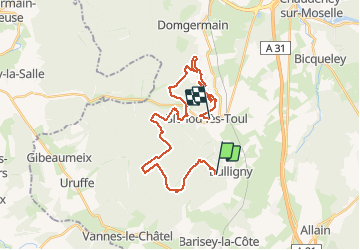

Length
27 km

Max alt
432 m

Uphill gradient
445 m
Km-Effort
34 km

Min alt
275 m

Downhill gradient
582 m
Boucle
No
Creation date :
2020-06-01 11:53:17.321
Updated on :
2020-06-01 15:54:45.713
2h24
Difficulty : Medium

FREE GPS app for hiking
 SityTrail
IGN / Geographical institutes
SityTrail Plus
The world is yours!
About
Trail Mountain bike of 27 km to be discovered at Grand Est, Meurthe-et-Moselle, Bulligny. This trail is proposed by JeanPierreNancy.
Positioning
Country:
France
Region :
Grand Est
Department/Province :
Meurthe-et-Moselle
Municipality :
Bulligny
Location:
Unknown
Start:(Dec)
Start:(UTM)
709601 ; 5384050 (31U) N.
Comments