


SityTrail - Tour des Fiz - Jour 1

Kargil
User GUIDE
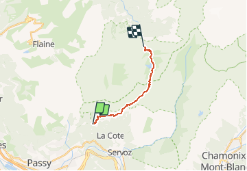

Length
11.8 km

Max alt
2253 m

Uphill gradient
985 m
Km-Effort
23 km

Min alt
1354 m

Downhill gradient
529 m
Boucle
No
Creation date :
2020-06-01 18:38:12.825
Updated on :
2020-06-01 18:46:18.487
4h53
Difficulty : Very difficult

FREE GPS app for hiking
 SityTrail
IGN / Geographical institutes
SityTrail Plus
The world is yours!
About
Trail Walking of 11.8 km to be discovered at Auvergne-Rhône-Alpes, Upper Savoy, Passy. This trail is proposed by Kargil.
Positioning
Country:
France
Region :
Auvergne-Rhône-Alpes
Department/Province :
Upper Savoy
Municipality :
Passy
Location:
Unknown
Start:(Dec)
Start:(UTM)
324823 ; 5091075 (32T) N.
Comments