


CROIX HANZO

surceneux
User

Length
11.6 km

Max alt
1088 m

Uphill gradient
386 m
Km-Effort
16.7 km

Min alt
815 m

Downhill gradient
386 m
Boucle
Yes
Creation date :
2020-06-01 14:06:18.023
Updated on :
2020-06-02 12:22:28.493
2h19
Difficulty : Medium

FREE GPS app for hiking
 SityTrail
IGN / Geographical institutes
SityTrail Plus
The world is yours!
About
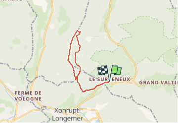
Trail Walking of 11.6 km to be discovered at Grand Est, Vosges, Ban-sur-Meurthe-Clefcy. This trail is proposed by surceneux.
Description
SURCENEUX FONIE PAR TRIANGLE BLEUCROIX HANZO CHALET PREUX ROCHE DES CHIEN FONIE PAR GR 533 RECTANGLE VERT SURCENEUX PAR TRIANGLE BLEU
Positioning
Country:
France
Region :
Grand Est
Department/Province :
Vosges
Municipality :
Ban-sur-Meurthe-Clefcy
Location:
Unknown
Start:(Dec)
Start:(UTM)
347831 ; 5329051 (32U) N.
Comments