


marche du 02 06 20 6.4 a 89

jtraverse
User
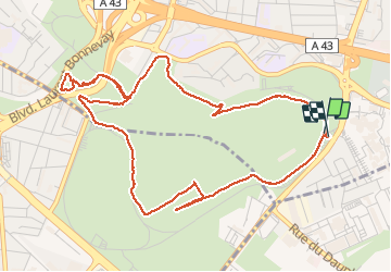

Length
6.4 km

Max alt
217 m

Uphill gradient
89 m
Km-Effort
7.6 km

Min alt
180 m

Downhill gradient
87 m
Boucle
Yes
Creation date :
2020-06-02 11:46:09.067
Updated on :
2020-06-19 13:26:58.166
2h23
Difficulty : Very easy

FREE GPS app for hiking
 SityTrail
IGN / Geographical institutes
SityTrail Plus
The world is yours!
About
Trail Walking of 6.4 km to be discovered at Auvergne-Rhône-Alpes, Métropole de Lyon, Bron. This trail is proposed by jtraverse.
Positioning
Country:
France
Region :
Auvergne-Rhône-Alpes
Department/Province :
Métropole de Lyon
Municipality :
Bron
Location:
Unknown
Start:(Dec)
Start:(UTM)
648897 ; 5064930 (31T) N.
Comments