


université Grenoble

meillon
User
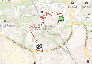

Length
1.7 km

Max alt
220 m

Uphill gradient
13 m
Km-Effort
1.9 km

Min alt
212 m

Downhill gradient
9 m
Boucle
No
Creation date :
2020-06-02 13:51:05.935
Updated on :
2020-06-02 15:59:28.868
38m
Difficulty : Very easy

FREE GPS app for hiking
 SityTrail
IGN / Geographical institutes
SityTrail Plus
The world is yours!
About
Trail Walking of 1.7 km to be discovered at Auvergne-Rhône-Alpes, Isère, Saint-Martin-d'Hères. This trail is proposed by meillon.
Positioning
Country:
France
Region :
Auvergne-Rhône-Alpes
Department/Province :
Isère
Municipality :
Saint-Martin-d'Hères
Location:
Unknown
Start:(Dec)
Start:(UTM)
717857 ; 5008015 (31T) N.
Comments