


boucle Rochefort

dan69390
User
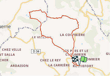

Length
9.7 km

Max alt
778 m

Uphill gradient
212 m
Km-Effort
12.5 km

Min alt
666 m

Downhill gradient
214 m
Boucle
Yes
Creation date :
2014-12-10 00:00:00.0
Updated on :
2014-12-10 00:00:00.0
2h30
Difficulty : Very easy

FREE GPS app for hiking
 SityTrail
IGN / Geographical institutes
SityTrail Plus
The world is yours!
About
Trail Walking of 9.7 km to be discovered at Auvergne-Rhône-Alpes, Rhône, Saint-Martin-en-Haut. This trail is proposed by dan69390.
Positioning
Country:
France
Region :
Auvergne-Rhône-Alpes
Department/Province :
Rhône
Municipality :
Saint-Martin-en-Haut
Location:
Unknown
Start:(Dec)
Start:(UTM)
622400 ; 5058488 (31T) N.
Comments