


track

bubuserge
User

Length
17.4 km

Max alt
44 m

Uphill gradient
108 m
Km-Effort
18.8 km

Min alt
24 m

Downhill gradient
107 m
Boucle
Yes
Creation date :
2020-06-03 16:44:57.331
Updated on :
2020-06-03 16:46:19.37
4h11
Difficulty : Difficult

FREE GPS app for hiking
 SityTrail
IGN / Geographical institutes
SityTrail Plus
The world is yours!
About
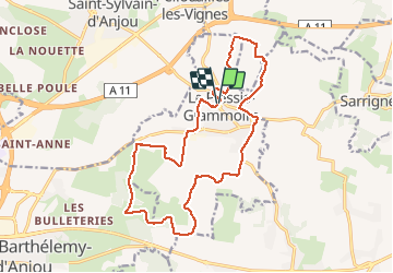
Trail Walking of 17.4 km to be discovered at Pays de la Loire, Maine-et-Loire, Le Plessis-Grammoire. This trail is proposed by bubuserge.
Positioning
Country:
France
Region :
Pays de la Loire
Department/Province :
Maine-et-Loire
Municipality :
Le Plessis-Grammoire
Location:
Unknown
Start:(Dec)
Start:(UTM)
693412 ; 5264048 (30T) N.
Comments