


les planches stmaur11juinok test 20.2d 620m

drarep
User
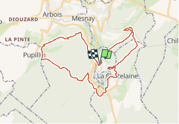

Length
20 km

Max alt
596 m

Uphill gradient
607 m
Km-Effort
28 km

Min alt
322 m

Downhill gradient
607 m
Boucle
Yes
Creation date :
2020-06-04 08:31:21.328
Updated on :
2020-06-06 08:08:48.034
5h58
Difficulty : Medium

FREE GPS app for hiking
 SityTrail
IGN / Geographical institutes
SityTrail Plus
The world is yours!
About
Trail Walking of 20 km to be discovered at Bourgogne-Franche-Comté, Jura, Les Planches-près-Arbois. This trail is proposed by drarep.
Description
Proposé par Philippe


Positioning
Country:
France
Region :
Bourgogne-Franche-Comté
Department/Province :
Jura
Municipality :
Les Planches-près-Arbois
Location:
Unknown
Start:(Dec)
Start:(UTM)
713774 ; 5195535 (31T) N.
Comments