


St régis

Martinechampailler
User

Length
18.2 km

Max alt
1303 m

Uphill gradient
467 m
Km-Effort
24 km

Min alt
1042 m

Downhill gradient
466 m
Boucle
Yes
Creation date :
2020-06-01 07:32:21.701
Updated on :
2020-06-04 08:42:06.919
5h02
Difficulty : Very easy

FREE GPS app for hiking
 SityTrail
IGN / Geographical institutes
SityTrail Plus
The world is yours!
About
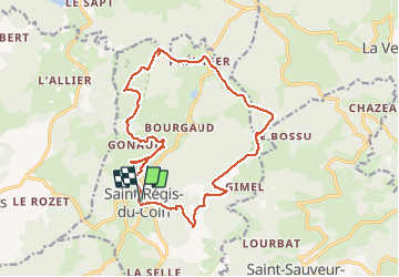
Trail Walking of 18.2 km to be discovered at Auvergne-Rhône-Alpes, Loire, Saint-Régis-du-Coin. This trail is proposed by Martinechampailler.
Positioning
Country:
France
Region :
Auvergne-Rhône-Alpes
Department/Province :
Loire
Municipality :
Saint-Régis-du-Coin
Location:
Unknown
Start:(Dec)
Start:(UTM)
613316 ; 5015477 (31T) N.
Comments