


Aix noulette 2

baclaude
User
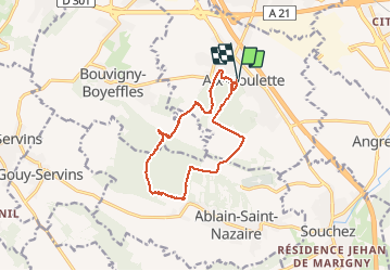

Length
12.2 km

Max alt
193 m

Uphill gradient
282 m
Km-Effort
16 km

Min alt
79 m

Downhill gradient
289 m
Boucle
Yes
Creation date :
2020-06-04 08:46:25.775
Updated on :
2020-06-04 11:24:03.052
2h36
Difficulty : Medium

FREE GPS app for hiking
 SityTrail
IGN / Geographical institutes
SityTrail Plus
The world is yours!
About
Trail Walking of 12.2 km to be discovered at Hauts-de-France, Pas-de-Calais, Aix-Noulette. This trail is proposed by baclaude.
Positioning
Country:
France
Region :
Hauts-de-France
Department/Province :
Pas-de-Calais
Municipality :
Aix-Noulette
Location:
Unknown
Start:(Dec)
Start:(UTM)
479582 ; 5585490 (31U) N.
Comments