


projet chalets de Furfande

orsel
User GUIDE
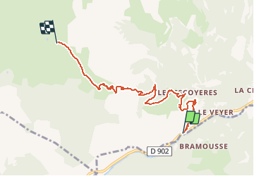

Length
7 km

Max alt
2288 m

Uphill gradient
1095 m
Km-Effort
18 km

Min alt
1191 m

Downhill gradient
5 m
Boucle
No
Creation date :
2020-06-04 12:27:17.999
Updated on :
2020-06-04 12:32:06.852
4h05
Difficulty : Difficult

FREE GPS app for hiking
 SityTrail
IGN / Geographical institutes
SityTrail Plus
The world is yours!
About
Trail Walking of 7 km to be discovered at Provence-Alpes-Côte d'Azur, Hautes-Alpes, Arvieux. This trail is proposed by orsel.
Positioning
Country:
France
Region :
Provence-Alpes-Côte d'Azur
Department/Province :
Hautes-Alpes
Municipality :
Arvieux
Location:
Unknown
Start:(Dec)
Start:(UTM)
321215 ; 4953434 (32T) N.
Comments