


Les berges du Caramy

Nathy8913
User
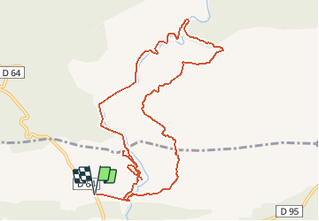

Length
12.1 km

Max alt
428 m

Uphill gradient
237 m
Km-Effort
15.3 km

Min alt
279 m

Downhill gradient
237 m
Boucle
Yes
Creation date :
2020-06-05 09:42:28.449
Updated on :
2020-06-05 09:43:18.006

FREE GPS app for hiking
 SityTrail
IGN / Geographical institutes
SityTrail Plus
The world is yours!
About
Trail of 12.1 km to be discovered at Provence-Alpes-Côte d'Azur, Var, Mazaugues. This trail is proposed by Nathy8913.
Points of interest


Positioning
Country:
France
Region :
Provence-Alpes-Côte d'Azur
Department/Province :
Var
Municipality :
Mazaugues
Location:
Unknown
Start:(Dec)
Start:(UTM)
736065 ; 4805454 (31T) N.
Comments