


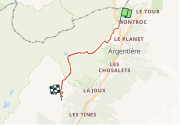
Tour des Aiguilles rouges - Tronçon 4 La Boërne à La Flégère

Kargil
User GUIDE

Length
7.4 km

Max alt
2359 m

Uphill gradient
974 m
Km-Effort
18.9 km

Min alt
1418 m

Downhill gradient
515 m
Boucle
No
Creation date :
2020-06-05 11:23:42.76
Updated on :
2020-06-05 16:27:55.566
3h54
Difficulty : Difficult

FREE GPS app for hiking
 SityTrail
IGN / Geographical institutes
SityTrail Plus
The world is yours!
About
Trail Walking of 7.4 km to be discovered at Auvergne-Rhône-Alpes, Upper Savoy, Chamonix-Mont-Blanc. This trail is proposed by Kargil.
Description
Du Gite La Boerne au Refuge de La Flégère.
Possibilité de dormir au Refuge du Lac Blanc (Environ 30 mn de moins)
Positioning
Country:
France
Region :
Auvergne-Rhône-Alpes
Department/Province :
Upper Savoy
Municipality :
Chamonix-Mont-Blanc
Location:
Unknown
Start:(Dec)
Start:(UTM)
339459 ; 5095762 (32T) N.
Comments