


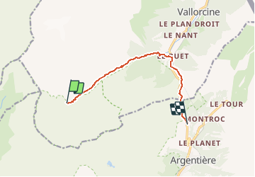
Tour des Aiguilles rouges - Tronçon 3 Pierre à Bérard à La Boërne

Kargil
User GUIDE

Length
8 km

Max alt
1934 m

Uphill gradient
126 m
Km-Effort
11.4 km

Min alt
1351 m

Downhill gradient
639 m
Boucle
No
Creation date :
2020-06-05 11:23:43.443
Updated on :
2020-06-05 16:26:30.123
2h05
Difficulty : Medium

FREE GPS app for hiking
 SityTrail
IGN / Geographical institutes
SityTrail Plus
The world is yours!
About
Trail Walking of 8 km to be discovered at Auvergne-Rhône-Alpes, Upper Savoy, Vallorcine. This trail is proposed by Kargil.
Description
Du Refuge de La Pierre à Bérard au Gite La Boërne du Hameau de Tré Le Champ

Positioning
Country:
France
Region :
Auvergne-Rhône-Alpes
Department/Province :
Upper Savoy
Municipality :
Vallorcine
Location:
Unknown
Start:(Dec)
Start:(UTM)
334977 ; 5096609 (32T) N.
Comments